No Fears - No Regrets
![]()
![]()

|
No Fears - No Regrets
|
|
| These are the RTB2004 Maps
Runner position distances for 12-person team
The following are general descriptions of each
leg and are intended to provide you with a preview of the Reach the Beach
route. Please use the course maps for specific navigation detail and elevation
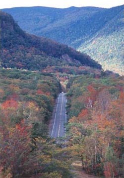
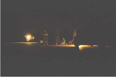
profiles. Leg 1 leaves the starting line at the Bretton Woods Ski Area Main Lodge and enters the nordic/cross country trails that encompass the mountain. The runners will weave their way towards the summit and then return to the lodge where the first transition exchange occurs. Topography: Welcome to New England! This will be hardest 5K you have ever run! Leg 2: (New!) 3.1 miles: elevation gain N/A: easy. [map] Leg 2 leaves the transition area at the Bretton Woods Base Lodge, winds its way through a nearby village of townhouses and eventually makes a right onto Rt. 302E until reaching the State Highway Depot . The relay exchange will occur on the RHS across from the parking lot. Topography: Gently rolling with a slight elevation drop. Shortest and easiest stage of the race. Leg 3: (New!)3.7 miles: elevation gain N/A: moderate. [map] Leg 3 leaves State Highway Depot along Rt. 302E where the road begins to drop in elevation until reaching the Willey House Historical Site on the right. Look for the old style train trestles dug into the side of the mountain on your right. Topography: Some steep descents throughout the leg. Leg 4: 5.4 miles: elevation gain N/A: moderate. [map] Similar to Leg 3. Relay transition occurs on the RHS across from the Davis Path parking area. Topography: Some steep descents throughout the leg. Leg 5: 8.6 miles: elevation gain N/A: hard [map] Leg 5 leaves the 4th transition area and continues along Rt. 302E into Bartlett, NH. Leg 5 is the longest of the RTB legs and begins with some steep descents but then flattens off for the remainder its duration. The transition will occur at the Attitash Ski Area on the RHS. Topography: This leg is rated ‘hard’ due to its length. Leg 6: 7.2 miles: elevation gain N/A: hard [map] Leg 6 leaves the Attitash Ski area and continues along Route 302 for approximately a half a mile before taking a right turn onto Westside Rd. Runners continue along Westside Rd for about 5.0 miles to another right turn onto Old Westside Rd. The course remains on this road for about half of a mile before reaching the transition area at Echo Lake State Park which is the first Vehicle Transition Area (VTA #1). Side Note: look for rock climbers scaling Cathedral Ledge on your right. Topography: This leg is rated hard due to its length. The terrain is mainly flat but has some steep descents along the way. This transition serves as a Vehicle Transition Area (VTA#1), and offers a place to park, rest and relax. Image: Aerial view of Route 302 (we don't know how our photographer got up there). But if you look really close, you can spot a runner on the left hand side of the picture (from last year's race).
Leg 7: 6.4 miles: elevation gain N/A: easy to moderate [map] Leg 7 leaves Echo State Park and takes a right turn back onto Westside Road. The course continues along this road for about five miles, coming to a traffic light in the center of North Conway at the intersection of Route 16. Runners continue through the light, crossing Route 16 for three tenths of a mile, taking a right turn onto Tasker Hill Road (Route 153). The 7th transition area is located on the right across from the American Legion parking lot. Topography: This leg is mainly flat. Leg 8: 8.8 miles: elevation gain 750 ft: extremely hard [map] Leg 8 (The Menagerie) leaves the transition area at the American Legion Hall and continues on Tasker Hill Road for about three miles. There are a few long, rolling hills before runners take a left turn onto Madock Hill Road. The road climbs steeply and then descends to an intersection where the runners will turn right as the support vehicles turn left. The runners will run along Ridge Rd and be treated to some spectacular scenery on this rarely traveled path before descending into the Town of Eaton. From there, the runners will continue on to the King Pine Ski Area on the right hand side. Topography: This leg has several substantial climbs and descents as well as dirt roads. However, the runner will be treated to fantastic views of several mountain ranges that line the route. Leg 9: 4.6 miles: elevation gain 500 ft: very hard [map] Leg 9 leaves the transition area and turns right onto East Madison Rd. From there, they will be "treated" to several steep climbs before reaching Rt. 113 where they will turn left and head towards the transition at the Madison Elementary School. Topography: Several steep climbs and descents. This is a leg breaker but the runners will have some awesome views.
Leg 10 (New!): 4.9 miles: elevation gain 400 ft: moderate [map] Leg 10 leaves the transition and continues along Route 113
for the entire leg, passing along Silver Lake for some great views. The runners
will cross Rt. 16 again and then make a quick right (still following Rt. 113)
until they reach Philbrook Road. They will turn right and go about .1 mile down
this dirt road where they will transition just beyond the entrance way to the
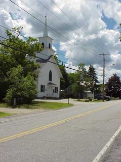
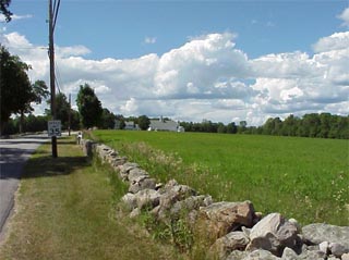
Brass Heart Inn . Image: Chochura Community Church just before crossing Rt. 16.
Leg 11 (New!): 5.5 miles: elevation gain 400 ft: moderate [map] Leg 11 continues on Route 113 and eventually turns left onto Page Hill Road. A short, steep climb will bring you to some great views before turning right onto Turkey Street. The leg continues along Turkey Street for one half mile before taking a right turn onto Maple Road and then another right turn onto Route 16. Travel on a wide shoulder along Route16 for about one half mile where you take a right turn into White Lake State Park and transition #11. Topography: Several climbs and decents. Leg 12: 4.0 miles: elevation gain 170 ft: easy [map] The runners for Leg 12 will leave White Lake State Park from the back entrance (vehicles will double back to Rt. 16) and turn right onto Depot Road. Continue along Route 16 for seven tenths of a mile before taking a right turn onto Depot Road. The course continues on Depot Road until the intersection with Tamworth Road where it turns left. Follow Tamworth Road for eight tenths of a mile before reaching the Kenneth Brett School and transition #12. This is VTA #2. Topography: This leg is very flat passing by horse farms and several mountain views. Leg 13 (New!): 8.5 miles: elevation gain 180 ft: easy [map] Leg 13 continues on Tamworth Road to a right turn onto Whittier Road. Continue on this road before taking a right turn onto Route 25. This leg remains on Route 25 for about 8 miles before making a right turn into the parking lot of R&B Antiques . . Topography: This leg is mainly flat but is rated hard due to its length.
Leg 14 (New!): 4.5 miles: elevation gain 530 ft: moderate-hard [map] Leg 14 leaves the transition and takes a right turn onto Evans Road. The course winds its way to Little Pond road where the runners will turn left and then eventually right turn onto Route 109. Continue on Rt. 109 for about 1.7 miles and take a left turn onto Squam Lake Road. Transition #14 is on the left at the Sandwich Center School. Topography: This leg is filled
with magnificent views of several ponds, majestic mountains and a quaint New
England Village complete with several white church steeples! That is well worth
the many steep ups and downs spread along the route. Leg 15 follows Squam Lake Road (also called Beane Rd.) meandering along the shoreline of Squam Lake for three miles. After passing Squam Lake, this leg passes Wakondoh Pond, beautiful fields and an old cemetery as you come into town and the 15th transition area at Center Harbor Christian Church on the left. Topography: The terrain has small to moderate rolling hills. Squam Lake is where the movie ‘On Golden Pond’ was filmed. Leg 16: 5.8 miles: elevation gain 560 ft: hard [map] Leg 16 leaves the transition and takes a quick right turn onto Kelsea Street and then another right onto Rt. 25B. Route 25B climbs steeply for .7 miles and is then followed by an equally steep decent of over a mile before intersecting with Route 3 where the runners will make a left and head towards the scenic town of Meredith and transition #16 at Prescott Park on the left. Topography: A long steep climb and descent are the highlights of this leg with fairly flat terrain making up the remainder. Leg 17: 6.1 miles: elevation gain 640 ft: moderate-hard [map] Leg 17 leaves transition area #17, crosses the dock area of Lake Winnepesake, and then climbs steeply for about a mile before turning right onto Route 106 (also known as Parade Road) and heads into Laconia. The Good Shepard Lutheran Church is about 4 miles down Rt. 106 on your right. Topography: The terrain has several good climbs and descents. Leg 18: 5.3 miles: elevation gain 330 ft: easy-moderate [map] Leg 18 continues on Route 106 for about 4 miles before joining Route 107 in down town Laconia. The runners will stay on Rt. 106 through the streets of the town center and eventually transition at the New Hampshire Technical College on the right hand side of Route 106 (just beyond the interchange with Rt. 3). This is also VTA#3. Topography: The majority of the leg has gently rolling terrain with the exception of a slight climb to the transition area. Leg 19: 7.0 miles: elevation gain 640 ft: very hard [map] Leg 19 leaves the college on Rt. 106 south and makes a left turn onto Plummer Hill Rd. followed by another left onto Cotton Hill Rd. before turning right onto Rt. 107. This leg contains several steep climbs and descents as you head into the Town of Gilmanton. The relay transition area is on your left at the Gilmanton Town Office building. Topography: The terrain consists of some steep rolling hills. Leg 20: 4.5 miles: elevation gain 300 ft: moderate [map] Leg 20 leaves the Town Offices and turns left onto Route 140 where it eventually stops at the Gilmanton School for the next transition. Topography: A gradual climb followed by a quick descent. More downhill than up. Leg 21: 6.4 miles: elevation gain 320 ft: moderate-hard [map] Leg 21 continues down Route 140 for about 1 mile and then vears right onto White Oak Road. It follows this quiet, country road for about 3 miles before reaching Route 28. At the intersection with Route 28, take a right turn and continue along Route 28 for ~1.5 miles to transition #21 at JJ Goodwins Eatery located on the left (note: the exchange occurs on the right). Topography: The terrain is mostly flat with a few small rolling hills but is identified as moderate to hard because of the distance. Leg 22: 6.8 miles: elevation gain 260 ft: easy-moderate [map] Leg 22 also follows Route 28 for its entire distance. The transition area is on the left side at Maria's Pizzaria but the runner exchange takes place on the right hand side of the road. Topography: Terrain is mainly flat with a few rolling hills. Leg 23: 4.9 miles: elevation gain 0 ft: easy [map] Leg 23 continues along Route 28 to the Country Cookin Restaurant located on the right. The transition exchange will occur in the parking lot on the right. (Side Note: there's a Dunkin Donuts open 24 hours just around the traffic circle beyond the transition). Topography: Terrain is mainly flat. Leg 24: 7.0 miles: elevation gain120 ft: easy-moderate [map] Leg 24 leaves the downtown area on Route 28 and heads back into the country. Runners will go pass Webster Park (on the left) at 2.4 miles and take a left turn onto Bear Brook Road at mile 5.7. Follow Bear Brook Road into Bear Brook State Park for transition area #24 - which will be the 3rd lot on the right. This is also VTA #4 and can accommodate camping. Topography: The terrain is flat with some small rollers during the final few miles. Image: Night time at Bear Brook State Park. Not shown is the huge outdoor fireplace located under the pavilion - a great place to warm-up and trade stories.
Leg 25: 8.8 miles: elevation gain TBD: hard [map] Leave Bear Brook campground on Bear Brook Road. The leg
continues on Bear Brook Road and makes a left onto Mt. Delight Road at 2.6
miles. The runners will follow this road for ~4.75 miles and make a right turn
onto Old Center Rd and onto TA25 which is located ~ 1 mile down the road at the
Deerfield Town Hall on the right.
Topography: This leg has many rolling hills. Leg 26: 8.5 miles: elevation gain TBD: hard [map] Leg 26 leaves the Deerfield Town Hall and turns right onto Rt. 43 (Candia Rd.). It veers to the right after about .9 miles and stays on Candia Rd. until reaching Middle Rd. where it turns right. The runners will follow Middle Rd. for ~1.5 miles and then turn left onto Birch Rd. After a short climb, the runners will turn left again onto South Road , go 1.6 miles and then turn right onto Route 43 heading south into Candia where they will transition at the Henry W. Moore School on the right. The Candia Volunteer Fire Department is directly across the road and is open for breakfast (at 4:00am!). Topography: This leg has a steep descent and several rolling hills. Leg 27: 8.6 miles: elevation gain 400 ft: very hard [map] Leg 27 leaves the Henry W. Moore School on Route 43 and crosses Route 27. Runners will then cross onto Main Street and turn left onto Chester Road where they will wind past farms and fields before turning left onto Route 121. The transition at Chester College of New England is on the left. Topography: This leg is rated as such due to its length (and the fact that it is your 3rd time around). Leg 28: 4.8 miles: elevation gain 250 ft: moderate [map] Leg 28 continues on Route 121 for about 2 miles and then turns right onto Wells Village Road heading south through winding roads before rejoining Route 121 (Main St) in the Town of Sandown where the runners will transition at the Sandown Town Hall on the right. Topography: This leg has a several rolling hills. Leg 29: ~4.1 miles: elevation gain 130 ft: moderate [map] Leg 29 follows Route 121A for about 1.9 miles and turns left onto Hawkwood Road. It stays on this road for about 2 miles before becoming Colbey Road. It intersects with Rt. 111A where the runners will turn left and transition at the 1st Baptist Church of Danville about .1 mile down on the right hand side. Topography: This leg has a several rolling hills. Leg 30: 5.1 miles: elevation gain 130 ft: easy [map] Leg 30 continues heading north on Rt. 111A for about .25 miles and then makes a right turn onto Pine St. From there the runners will travel this rural back road for another 1.25 miles and turn right onto Old Mill/Cheney Rd. After about a mile you will then veer to the left onto Danville Rd. and then make a left onto Page Rd./ Rt. 111. The runners will follow Rt. 111 for about 2.0 miles before making a quick left onto West Main St. where they will find the entrance to Kingston State Park on the left hand side; this is also VTA#5. Topography: This leg is mainly flat. Leg 31: 7.2 miles: elevation gain 300 ft: moderate [map] Runners will leave transition number 31on Route 111 and will head east towards the Town of Exeter where they will transition at the Exeter Jr. High School on the right. Topography: This leg is mainly flat with a "few rolling hills". Leg 32: 4.2 miles: elevation gain 200 ft: easy [map] Leg 32 continues on Linden Street and quickly intersects with Route 111 where the runners will turn right and follow through downtown Exeter. Use caution - there are a lot of pedestrians and cars. The runners will stay on Route 111, pass under Rt. 101 and make a left onto Marin Way. They will then take their next left and go to Transition 32 at the Timberland Corporate Headquarters on the left hand side. Topography: This leg is mainly flat. Leg 33: 3.5 miles: elevation gain 120 ft: easy [map] Leg 33 leaves the transition at the Industrial Park remains on Route 111 for 2.4 miles. Transition number 33 is at the North Hampton School on the left hand side. Hurray - a short stage! Topography: This leg is mainly flat. Leg 34: 4.6 miles: elevation gain 140 ft: easy [map] Leg 34 leaves the North Hampton School and turns left onto Mill Street. They are now getting close to the ocean and will wind their way through some gorgeous seacoast neighborhoods. The runners will emerge on Washington Street and turn right and will follow this through the town for about 1.6 miles to their next Transition Area at the Rye Jr. High School on the left hand side. Topography: This leg is mainly flat with a "few rolling hills". Leg 35 : ~6.5 miles: elevation gain 0 ft: easy [map] After transition at the high school, the runners will cross to the right side of Washington St. and follow it for about 1.5 miles to Rt. 1A and the New Hampshire coast line. The runners will turn right and follow Route 1A to Transition 35 at the North Hampton State Beach on the left hand side. Topography: Mainly flat but windy with spectacular ocean views! Leg 36: 5.0 miles: elevation gain 0 ft: easy [map] The final leg follows Route 1A along the shoreline, past beach houses and mansions into the downtown area. The road splits off after 3 miles and the last 2 miles follow the seashore right to Hampton Beach State Park and the Finish! Runners are to stay to the left and follow the sidewalks. Topography: Mainly flat but windy with spectacular ocean views! Vehicle Transition Areas (VTA) - $General Description The VTA's are those locations where vehicle rotations take place from the first half and second half of your team; i.e., the first 6 runners and the next 6 runners. These are the primary support locations for all teams. Each VTA will contain an abundance of restroom facilities, food and water/hydration stations, as well as parking locations for your vehicles (most locations can accommodate camping as well). Though there will be restroom facilities at most
transition areas, the DRA's were selected due to their ability to accommodate
your entire team rather than an individual runner. Your team will be able to
catch up on sleep and recover at these locations. |
|
Send mail to
info@nofearsnoregrets.com
|